Cutting-Edge Research
in Kyoto University
GEO-PHYS
Seeing Underground with Seismic Waves Imaging the Philippine Sea plate subducting beneath southern Kyushu.
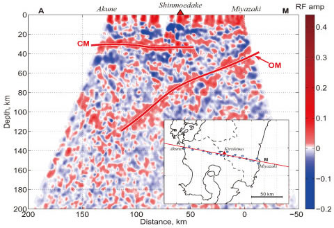
What is occurring under the ground beneath southern Kyushu, where a Nankai Trough megaquake could occur and magma is generated beneath the Sakurajima and Kirishima volcanoes? Using seismic waves, we try to see the earth’s interior, through which light cannot propagate. Since 2010, we have deployed seismometers with an average spacing of 5km from Miyazaki to Akune via the Kirishima volcano. We have analyzed P waves from large earthquakes in distant regions, such as Indonesia, extracted S waves which were converted from the P waves at seismic velocity discontinuities, such as the top surface of the Philippine Sea plate, and obtained an image of the geometry of the discontinuities. We have successfully imaged the oceanic Moho (OM) in the subducting plate and the continental Moho (CM) in the western part of southern Kyushu, both of which are boundaries between the crust and the mantle.

- Takuo Shibutani, PhD
- Chief and Professor, Tottori and Miyazaki Observatories, Research Center for Earthquake Prediction, DPRI